
COMIENZAN A DINAMITARSE LAS REPRESAS DE LOS RIOS DEL SALMON
When crews tear down Elwha and Glines Canyon dams in Washington next year, they may want to study how Portland General Electric removed Oregon´s Marmot Dam.
EL MUNDO DESARROLLADO SE DESHACE DE LAS GRANDES REPRESAS ... EL MUNDO SUBDESARROLLADO EMPRENDE UNA FEBRIL Y DESCABELLADA CONSTRUCCIÓN DE GRANDES REPRESAS ...
¿PORQUE SERÁ?
¿NO HAY CONEXIÓN ENTRE UNA Y OTRA COSA?
O...QUIZÁ ANDAMOS COMO EL CANGREJO....
DINAMITAN LAS GRANDES REPRESAS DE ELWHA Y CANON DAM EN OREGON
Las represas Elwha y Canyon Dam se construyeron en 1913 y 1927 cona una altura de 32 y 64 metros, respectivamente, para proporcionar energía eléctrica para las empresas madereras locales. Las represas bloquean el suministro natural de sedimentos a la parte baja del río y a la costa, provocando cambios en la llanura de inundación y erosión de las playas del lado este en la desembocadura del río. Debido a que las represas se construyeron sin paso de peces, se ha limitado en gran medida las rutas disponibles de desove del salmón y trucha arco iris, los peces que pasan la mayor parte de su vida en el océano, pero vuelven a la corriente donde nacieron para reproducirse. Estas poblaciones nativas de peces han disminuido gravemente en la cuenca Elwha y en todo el noroeste del Pacífico, debido en parte a las pérdidas y daños relacionados con el represamiento de su río de desove. En la actualidad el salmón, la trucha arco iris tienen sólo 7.8 kilometros del río para desove (la distancia desde la desembocadura del río a la represa Elwha). Después de retirar la represa, más de 70 km del río finalmente deben reconvertirse en hábitat utilizable para estos peces.
LA REPRESA MARMOT EN SANDY RIVER YA FUE DINAMITADA POR IDENTICAS RAZONES
 Schematic map of northwestern Washington, showing locations of Elwha and Glines Canyon Dams on the Elwha River
 http://www.crrel.usace.army.mil/sid/Dam_decom/images/MarmotDam_r.jpg
 http://sns.ucdavis.edu/public/user/images/lifecycle_of_salmon.jpg

Salmon and steelhead

Salmon and steelhead, species of anadromous fish, once were prolific in the Columbia River. Based on late 19th-century cannery records and Indian accounts, it is believed that some 10 million to 16 million adult salmon and steelhead returned to the river each year to spawn prior to about 1850, when European emigration into the basin began to accelerate, and with it the exploitation of salmon. In modern times, by comparison, the returns rarely top 2 million per year.

Six species of Pacific salmon are known to have inhabited the Columbia River Basin historically. These are Chinook, coho, sockeye, chum and pink salmon, and steelhead. Steelhead were grouped with trouts in the Salmo genus until the 1990s, when they were reclassified in the Oncorhynchus genus with salmon.
Oncorhynchus means “hooked snout,” a physical characteristic of adult salmon when they are ready to spawn. Five of the six species still are found in the Columbia River. Columbia River pink salmon are extinct, but pinks are prolific in rivers farther north, in British Columbia and Alaska.
The ancestors of modern Columbia River salmon probably evolved around 25-35 million years ago during the late Oligocene period. However, the fossil record of anadromous fish in the Columbia and Snake rivers dates to 7-10 million years ago, a period when both rivers ran to the sea (the Snake entered the ocean in present-day northern California). Scientists disagree whether salmon — in the Columbia River and elsewhere — evolved in freshwater or saltwater. The archaeological evidence leans toward freshwater because the fossil record suggests the freshwater residence of salmon predates their saltwater residence.
www.nwcouncil.org/history/salmonandsteelhead.asp
--------------------------------------------------------------------------------------------------------------------

TIM KELLER
"What PGE learned while removing Marmot Dam
Some of those lessons could be applied to other projects; including no two dam removals are alike.
By TIM KELLER
Portland General Electric
October 28, 2010
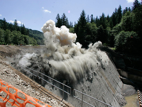
The dam was fractured by drilling, and then controlled blasting.
What PGE learned while removing Marmot Dam
Some of those lessons could be applied to other projects; including no two dam removals are alike.
By TIM KELLER
Portland General Electric
With the Elwha and Glines Canyon dams set for removal next year in Washington, attention is turning to how such massive structures are actually taken down. One of the most recent dams removed in the Northwest was Marmot Dam on Oregon’s Sandy River.
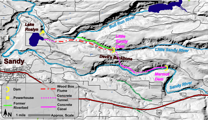
Portland General Electric in 2007 removed Marmot Dam, which was part of the Bull Run Hydroelectric Project.
In November of 1999, PGE filed a notice not to seek a new federal license for the Bull Run project near the city of Sandy. PGE decided that it would not make sense to upgrade the nearly century-old facility to meet current standards for protection, mitigation and enhancement of the natural resources affected by the project — especially salmon and steelhead runs on the Sandy River. The likely cost would outweigh the economic benefit to PGE customers from power generation at the project. The Bull Run project was located about 30 miles east of Portland on the western slopes of Mount Hood, and consisted of:
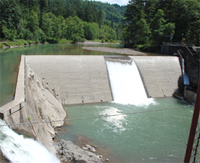
• Marmot Dam, a 47-foot-high, 345-foot-long roller-compacted concrete dam that was built in 1989 to replace an earlier timber structure.
Marmot Dam was a 345-foot-long roller-compacted concrete dam built in 1989 on the Sandy River.
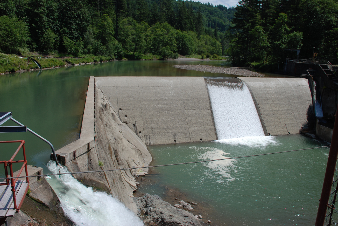
The view downstream after the dam was removed.
• Little Sandy Dam, a small concrete diversion dam on the Little Sandy River.
• A complex system of connecting canals and flumes.
• A 22-megawatt powerhouse.
• Roslyn Lake, a 160-acre forebay located 320 feet above the powerhouse.
Water was diverted from the Sandy and Little Sandy rivers to Roslyn Lake. From there, flow was delivered to the powerhouse and then discharged to the Bull Run River after passing through power-generating turbines.
Approximately 980,000 cubic yards of sediment — silt, gravel, cobbles and boulders — had accumulated behind Marmot Dam during its lifetime.
After convening a group to develop a decommissioning and removal plan — a process involving 23 governmental and nonprofit organizations and literally years of collaborative effort — PGE committed to removing the dam within one construction season in 2007, extracting only as much sediment as was required for the demolition. The remaining sediment would be allowed to disperse with natural stream flow.
PGE and stakeholders hoped that this approach would minimize the impact of excavation and truck traffic on the riverbed and surrounding landscape. It would also minimize transportation costs that would ultimately be borne by PGE customers.
 The dam was fractured by drilling, and then controlled blasting.
PGE solicited bids for Marmot Dam removal in March of 2007, requiring bidders to follow a predetermined format with information on pricing, labor and equipment rates, a hazardous material plan, a demolition plan, project schedule, risk analysis and qualifications.
PGE then evaluated bids and awarded the contract to Natt McDougall Co. Work began almost immediately.
To allow demolition of the instream structures, workers placed a cofferdam upstream and another downstream of the dam. Project engineers designed the cofferdams to fail during normally high stream flows expected to occur in the fall after the dam was scheduled to be removed.
After work was completed on the cofferdams and the river water diverted around the work area, excavators removed the sediments behind the dam. Then, the dam was fractured by drilling and controlled blasting operations and removed by excavators as well.
When forecasts called for river flows above 1,500 cubic feet per second on Oct. 19, 2007, PGE and McDougall prepared to initiate the cofferdam breach. Using a forklift, McDougall workers removed dewatering pumps that had been installed to assure the integrity of the upstream cofferdam and started scraping a notch in the cofferdam down to water level with the machine. As flow through the notch increased it quickly cut away sediment, taking less than 30 minutes to reach full flow diversion.
This flow was also enough to breach the downstream cofferdam, allowing maximum sediment transport and timely creation of a passable channel though the sediment for salmon.
Since the breach, the movement of the sediments and fish migration has been monitored by PGE, research groups, federal and state agencies. The consensus is that the recuperative power of the Sandy River proved to be much greater than expected in such a short time.
Here are the lessons learned:
1. Form a strong project team. The project team managed by PGE consisted of engineering design and research firms, biologists, hydrologists and fisheries experts. Coordinated by PGE’s hydro licensing staff, there were several sessions during the design process to inform, gather consensus and work through the more difficult issues, which usually were fish passage details.
2. Get early feedback and involvement from all permitting agencies. Even with biological opinions in place from the state and federal fish management agencies, the joint permit application to the Oregon Department of State Lands and the Army Corps of Engineers required PGE to perform a more stringent sedimentation analysis and resulted in a one-year delay to the start of decommissioning. Getting early feedback and involvement is essential to ensure a timely and cost-effective result.
3. Contractor selection is critical. The selection of a trustworthy contractor who will work closely with the owner to develop efficient work strategies is a key element of any project’s success and was especially important for the Marmot Dam removal. McDougall provided valuable insight and worked with PGE to minimize the overall project cost and impacts while fulfilling decommissioning commitments.
4. Plan ahead. Planning for the Marmot Dam removal incorporated all concerns introduced by federal and state agencies as well as the project team. This included contingency planning in case events did not unfold as expected.
5. Demolition is not an exact science. Engineers design a structure like Marmot Dam conservatively; it takes knowledge, experience and good judgment to determine how best to apply enough but not too much force to demolish it.
6. Be ready to adapt quickly. The Sandy River has more than 90 years of historical river flow data and PGE had access to state-of-the-art flow predictions and forecasts. Even so, flows could not be accurately predicted more than 12 hours in advance. The contractor had to be able to respond with short notice to initiate the breach procedure.
7. Prepare for the impact of news media and researchers. There was a concern that the news media and researchers would slow the project. Careful planning and centralized communications with the media alleviated any problems. There was a small impact on productivity as PGE responded to news media and stakeholder interest in viewing the first blast event.
8. Work early and cooperatively with the ultimate land owner. In this case the land owner was the federal Bureau of Land Management. BLM explained its plans to PGE, helping to avoid unnecessary work through site visits and design coordination.
Another, more general lesson illustrated by the decommissioning process at the Bull Run Hydroelectric Project is that no two projects are alike.
Decommissioning and removal of Marmot Dam was a success for both PGE’s customers and the environment, and PGE worked closely with government agencies, advocacy groups and technical experts to assure that the plan was executed smoothly. The results exceeded expectations and provide a model for other dam removal projects.
PGE has faced relicensing at other hydroelectric projects in recent years, however, and found that the same kind of cost and benefit analysis can yield very different results at different facilities.
At PGE’s T.W. Sullivan Plant on the Willamette River, the company opted to make significant investments in upgraded fish passage facilities, because analysis showed that the improvements would benefit customers even though the hydroelectric plant was actually older than Bull Run’s.

The view downstream after the dam was removed.
And at the Pelton Round Butte Hydroelectric Project on the Deschutes River in Central Oregon, PGE completed a one-of-a-kind fish passage and water temperature management facility last year. PGE is also committed to a comprehensive strategy of helping to improve habitat and reintroduce fish runs that were blocked when the project was constructed in the 1960s.
Improvements at the Sullivan Plant and Pelton Round Butte have earned both projects Low Impact Hydro certification.
In each case, the goal has been to produce the same win-win result for PGE customers and the environment, but the strategy chosen to get there was developed to fit the specific circumstances. The common element is that PGE has conducted extensive outreach and engaged stakeholder groups and government agencies to assure that all perspectives are taken into account and every effort is made to address potential questions, concerns and problems as the process unfolds.
That’s true for the planning stages, and — as demonstrated by the Marmot Dam decommissioning — carries through to implementation of the resulting plan.
Tim Keller is a construction manager with Portland General Electric’s Power Supply Engineering Services group. He has 30 years of construction and project management experience at PGE.
Studying the Elwha River, Washington, in Preparation for Dam Removal
By Amy Draut
Nov. / Dec. 2006 in this issue:
previous story | next story

Above: Elwha Dam, the lower of two dams on the Elwha River in northwestern Washington scheduled for removal. Spillway on right side of photograph has eroded substantially, and rounded pieces of concrete from dam are a common component of sediment in recent study's first survey reach downstream of dam. [larger version]
Above: Schematic map of northwestern Washington, showing locations of Elwha and Glines Canyon Dams on the Elwha River. (Modified from map by Bureau of Reclamation, posted online.) [larger version]
Above: Josh Logan surveying part of Elwha River channel, in the intertidal zone. [larger version]

Above: Tom Reiss surveying a section of the lower Elwha River and coastal zone. 
--------------------------------------------------------------------------------

In a few years, the Federal Government will begin the biggest dam removal in U.S. history, restoring a major coastal watershed and its prized salmon river on the Olympic Peninsula, Wash. U.S. Geological Survey (USGS) scientists are already working on the Elwha River Restoration Project, which has been in the works for many years, being planned by organizations that include the National Park Service (NPS), the Bureau of Reclamation, and the Lower Elwha Klallam Tribe. The project will involve removing two large dams on the Elwha River to help restore this stream and the associated coastal zone to a more natural state and to improve ecosystem health (see related Sound Waves article, "Dam Removal on the Elwha River in Washington—Nearshore Impacts of Released Sediment").
Elwha and Glines Canyon Dams were completed on the Elwha River in 1913 and 1927 at heights of 32 and 64 m, respectively, to provide hydropower for local timber companies. The dams blocked the natural supply of sediment to the lower river and coast, causing changes on the flood plain and erosion of beaches downdrift (east) of the river mouth. Because the dams were built without fish passage, their presence has greatly limited the available spawning run for salmon and steelhead, fish that spend most of their lives in the ocean but return to the stream where they hatched in order to reproduce. These native fish populations have declined severely in the Elwha watershed and around the Pacific Northwest, owing partly to the dam-related loss of their river spawning habitat. At present, salmon and steelhead have only 7.8 km of the river to use as spawning habitat (the distance from the river mouth to Elwha Dam). After dam removal, more than 70 km of the river should eventually become usable habitat for these fish.
In 2000, the Federal Government purchased Elwha and Glines Canyon Dams from the timber companies that formerly owned them. It was agreed that because both dams were aging and needed costly repairs, a better alternative to repairing them would be to remove them and thereby restore the river habitat. Dam removal will take place in stages over 2 years and is scheduled to begin in 2009. This will be the first watershed-restoration project in which dams this large will be removed, and so it presents a unique opportunity to study how a river and coastal system respond to the changes that will follow dam removal, especially the reintroduction of sediment as the river erodes much of the sediment now trapped in the two reservoirs. More than 80 percent of the Elwha watershed lies within the boundary of Olympic National Park and has never been developed. It is hoped that dam removal will improve not only the native fish populations but also the general condition of the ecosystem in this largely pristine area.
Scientists from the USGS Western Coastal and Marine Geology (WCMG) team are part of a large, interdisciplinary group of researchers studying the Elwha watershed as agencies gear up for dam removal. In September 2006, Amy Draut, Tom Reiss, and Josh Logan conducted the first of numerous planned USGS surveys of the river channel. They documented channel topography and sediment grain size in three study areas between Elwha Dam and the river mouth. They also surveyed part of the river channel upstream of both dams, at a site in Olympic National Park, to use as a "control" area to monitor changes in channel form and sediment unrelated to the dams or dam removal. These four sites will be revisited twice a year, in spring and fall, to document the magnitude of changes that occur seasonally in the dammed system. After dam removal begins, the scientists will continue to monitor these areas to evaluate how the river and intertidal zone change when the reservoir sediment begins to move downstream.
In addition to the research in the river channel and intertidal zone, WCMG scientists Guy Gelfenbaum, Guy Cochrane, Jon Warrick, and Dave Rubin are leading mapping and oceanographic profiling in the nearshore zone and farther offshore along the coast. USGS specialists in biology, hydrology, and geography are also conducting studies related to dam removal. USGS scientists are working closely with the Lower Elwha Klallam Tribe, the National Oceanic and Atmospheric Administration (NOAA), and the NPS to learn as much as they can from this first-of-its-kind comprehensive watershed-restoration experiment.
For more information, visit Elwha River Restoration and Elwha River Restoration Project or contact Amy Draut at adraut@usgs.gov or 831-427-4733.
Dam Removal on the Elwha River in Washington—Nearshore Impacts of Released Sediment
February 2005
![]()
in this issue:
 previous story
![]()

Above: Map of the Elwha River region. [larger version]
The Elwha River drains the rugged Olympic Mountains of Washington, flowing northward to the Strait of Juan de Fuca. Construction of two hydroelectric dams in the early 1900s resulted in the loss of approximately 95 percent of the anadromous salmon spawning habitat on the river. In 1992, the Elwha River Ecosystem and Fisheries Restoration Act was enacted by Congress to authorize removal of the dams in order to restore the once-plentiful salmon runs in the river. Dam removal is currently slated to begin in early 2008.
As well as restoring salmon runs, dam removal on the Elwha River will expose more than 14 million m3 of sediment deposited in the deltas within the two reservoirs. The sediment-management strategy is to allow the material to be naturally eroded and transported to the Strait of Juan de Fuca, acknowledging that some sediment will remain in place and be deposited in the river channel and flood plain. Contributions of sediment to the strait may end or even reverse the current trend of coastal erosion near the river mouth. Sediment contributions may also bury or alter nearshore habitats (including kelp beds and geoduck clam burrows) offshore of the river mouth.