Grandes represas serán destruidas para la Restauración del Río Elwha y el retorno de los salmones
Dams Removal on the Elwha River in Washington.
Estados Unidos está expectante a poco del inicio de la eliminación de represas más grande del país, en el Valle Elwha.
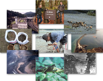
La Restauración del Río Elwha devolverá al río su estado natural, permitiendo que fluya libremente, permitiendo que las cinco especies de salmón del Pacífico y otros peces, llegen nuevamente a sus ancestrales hábitats y zonas de desove.
Restoring the Elwha
A new video about the Elwha River includes computer-generated animations created by American Rivers that show the Elwha Valley before, during and after dam removal. The video, produced by Earth Tribe TV, provides a good summary of the river and its people and discusses the dam removal scheduled to begin in 2009. American Rivers staff used special computer modeling software to create the 3-D photo-realistic visualizations that appear in the video.
22-3-2011- PORT ANGELES — The National Park Service has reduced the cost estimate for the mammoth Elwha River Restoration Project, which includes the removal of the streams' two dams. The project is estimated to cost $324.7 million, said Dave Reynolds, Olympic National Park spokesman. That's down from the previous estimate of $351 million.

DESTRUCCIÓN DE LA REPRESA "RÁPIDOS SALVAJES" EN EL RÍO ROUGUE
.
ANNIMATION _ Elwha River Restoration Project: Elwha Dam Removal - Courtesy of Olympic National Park.

La cuenca Elwha es la más grande en la reserva Olympic National Park; el restablecimiento de las rutas del salmón, en más de 70 millas de ríos y afluentes, devolverá los nutrientes vitales para la cuenca y restaurará el ecosistema. Para la tribu Klallam del bajo Elwha, este proyecto traerá salud cultural, espiritual y económica con el retorno del salmón después de una ausencia de un siglo, cuando sus sitios sagrados desgraciadamente inundados, se restauren.
 El río Elwha drena las escarpadas Olympic Mountains de Washington, que fluyen hacia el norte por el Estrecho de Juan de Fuca. La construcción de dos represas hidroeléctricas en el año 1900 dio lugar a la pérdida del 95% del hábitat de desove en el río de los salmones anádromos (salmones que viven en el mar pero regresan a desovar en lo alto de los ríos donde nacieron). En 1992, COMPRENDIENDO EL GARRAFAL ERROR EN QUE SE HABÍA INCURRIDO AL CONSTRUIR LOS FARAÓNICOS EMBALSES, se promulgó la ley “Elwha River Ecosystem and Fisheries Restoration Act” aprobada en el Congreso, una Ley de Pesca para autorizar la demolición de las represas a fin de restablecer el salmón, en otro tiempo abundante en el río Elwha.

La eliminación de las represas en el río Elwha hará regresar al salmón, pero liberará más de 14 millones de m3 de sedimentos depositados en los dos embalses. La estrategia de gestión de los sedimentos es permitir que el material se vaya naturalmente, que sea erosionado y transportado hasta el Estrecho de Juan de Fuca, favoreciendo que parte de los sedimentos se mantengan en su lugar y se depositen en el cauce del río y en las llanuras de inundación aledañas. Los aportes de sedimentos al estrecho puede terminar con la actual erosión costera o incluso invertir la tendencia de erosión actual cerca de la desembocadura del río Elwha. Los aportes de sedimentos también puede enterrar o alterar los hábitats cercanos a la costa (incluidos los lechos de algas marinas y bancos de almejas geoduck), mar adentro, en la desembocadura del río.

http://www.hydroreform.org/sites/www.hydroreform.org/files/
Los científicos del Servicio Geológico de EE.UU. (USGS), han comenzado la investigación para caracterizar los impactos cerca de la costa de la voladura de las represas, como parte del Proyecto de Manejo de Hábitats Costeros en la bahía Puget Sound (USGS Coastal Habitats in Puget Sound Project) . Los científicos del proyecto han estado trabajando estrechamente con las organizaciones locales, tribales, estatales y federales para desarrollar, coordinar, monitorear y modelar planes. Dentro de la USGS, los científicos del Programa Geológico Costero y Marino, que están financiando el proyecto, están trabajando con el hidrólogo Chris Konrad, el biólogo Jeff Duda, y el geógrafo Harvey Case para desarrollar un plan científico coordinado del río Elwha que lige la investigación fluvial, ecológica y costera.
.

.

.
 .
.
Dam Removal on the Elwha River in Washington—Nearshore Impacts of Released Sediment
February 2005


Above: Map of the Elwha River region. [larger version]
The Elwha River drains the rugged Olympic Mountains of Washington, flowing northward to the Strait of Juan de Fuca. Construction of two hydroelectric dams in the early 1900s resulted in the loss of approximately 95 percent of the anadromous salmon spawning habitat on the river. In 1992, the Elwha River Ecosystem and Fisheries Restoration Act was enacted by Congress to authorize removal of the dams in order to restore the once-plentiful salmon runs in the river. Dam removal is currently slated to begin in early 2008.
As well as restoring salmon runs, dam removal on the Elwha River will expose more than 14 million m3 of sediment deposited in the deltas within the two reservoirs. The sediment-management strategy is to allow the material to be naturally eroded and transported to the Strait of Juan de Fuca, acknowledging that some sediment will remain in place and be deposited in the river channel and flood plain. Contributions of sediment to the strait may end or even reverse the current trend of coastal erosion near the river mouth. Sediment contributions may also bury or alter nearshore habitats (including kelp beds and geoduck clam burrows) offshore of the river mouth.
U.S. Geological Survey (USGS) scientists have begun research to characterize the nearshore impacts of the Elwha River dam removals as part of the USGS Coastal Habitats in Puget Sound project. Project scientists have been working closely with local, tribal, State, and Federal parties to develop coordinated monitoring and modeling plans. Within the USGS, scientists from the Coastal and Marine Geology Program, which is funding the project, are working with hydrologist Chris Konrad, biologist Jeff Duda, and geographer Harvey Case to develop a coordinated Elwha River science plan that links fluvial, ecological, and coastal research.
As part of this coordination, USGS geologist Jon Warrick participated in the "Technical Workshop on Nearshore Restoration in the Central Strait of Juan de Fuca" held March 2004 in Port Angeles, WA, where ecologists, fishery scientists, engineers, and geomorphologists agreed on the high-priority need for a conceptual model of sediment transport and deposition off the Elwha River. Since this workshop was held, the USGS has led efforts to develop both a simple conceptual model of sediment transport and a research plan for quantifying sediment-transport rates and pathways.


Above Left: The Elwha River (mouth in foreground) flows into the Strait of Juan de Fuca from Washington's Olympic Mountains (background). [larger version]Above Right: Simple conceptual model of sediment transport offshore of the Elwha River. Potential pathways of sediment (arrows) may be along the shore or cross-shore down the submarine delta.
The USGS Coastal Habitats in Puget Sound Project will employ three major techniques to evaluate dam-removal impacts: mapping, monitoring, and modeling. The mapping work will focus on collecting baseline bathymetric and seabed information from which changes can be tracked through the dam-removal process. Two mapping techniques are being used. In March 2004, Guy Cochrane, Jon Warrick, Jodi Harney, Andy Stevenson, Larry Kooker, Mike Boyle (all of the USGS), and Tina Blewett (Washington Department of Fish and Wildlife) used combined swath-sonar, seabed video, and seabed grain-size sampling techniques from the research vessel Karluk to map the nearshore region off the Elwha River mouth. Preliminary results show that the substrate from the river mouth out to approximately 30-m water depth consists of mixed sand and gravel, with areas of large sand waves (approx 10 m high) and some boulder fields.
In September 2004, Guy Gelfenbaum, Peter Ruggiero, Jodi Eshleman (all USGS), and Etienne Kingsley (Washington Department of Ecology) conducted bathymetric and topographic mapping, using a second mapping technique that relies on satellite-based global-positioning-system (GPS) units on land and in watercraft. More than 100 shoreline cross sections were obtained in the September mapping exercises, which will be repeated twice per year through the dam removal. These measurements—along with beach surveys by the Lower Elwha Klallam Tribe at seven sites and aerial photography by the Surfrider Foundation—will be the primary method of tracking changes offshore of the Elwha River mouth.


Above Left: Preliminary results of the swath-sonar backscatter mapping (which records the intensity of sound energy reflected from features on the sea floor), showing large sand waves (dark color) over a region of mixed gravel and sand (bright colors). Water depth of observations is approximately 5 m. [larger version]Above Right: Combined bathymetric and topographic data for the area of the Elwha River mouth. Bathymetry of the delta is from swath-sonar and GPS measurements. Topography of the land surface is from lidar (light detection and ranging) measurements provided by the Lower Elwha Klallam Tribe. View southeastward. Image created by Peter Dartnell (USGS). [larger version]
Because oceanographic information about the strait is very limited, the USGS research project will also monitor and numerically model waves and currents in the region offshore of the river mouth. Oceanographic monitoring will begin during spring 2005 with deployments of acoustic Doppler current profilers (ADCPs) and directional wave gauges, which will be used to develop an understanding of waves, tides, and currents that may affect the sediment released by dam removal.
Observations of physical conditions off the river mouth will be used to calibrate and validate a three-dimensional hydrodynamic model of the Elwha River area of the strait currently being developed by Guy Gelfenbaum and Giles Lesser with Delft3D modeling software. Modeling is an important part of the research plan because wave and current conditions along the river-mouth delta are expected to vary widely, owing to the complex bathymetry of the submarine delta offshore of the present river mouth. Preliminary results of the circulation modeling show strong eddies offshore of the river mouth, features that are commonly encountered by local fishermen.
The planned mapping, monitoring, and modeling will help characterize the pathways and fate of sediment released from behind the dams of the Elwha River. This information will be crucial in evaluating the impacts of dam removal on the substrate and habitats of the beaches and the nearshore.

Datos batimétricos y topográficos combinados del área del delta del río Elwha. La batimetría del delta empleó sonar de franja y mediciones GPS. La topografía de la superficie terrestre es LIDAR y las mediciones fueron realizadas por la tribu Klallam del bajo Elwha
 http://www.elwhainfo.org/files/Image/big_logo-white_background_2.jpg

Checking on fish produced by the captive brood program of the Lower Elwha Klallam Tribe.

-
 Acuarela de James Gilchrist Swan (1818-1900) de la nación Klallam comandada por el jefe Chetzemoka (apodado el Duque de York), con una de sus esposas (apodada Jenny Lind) distribuyendo potlatch en Port Townsend, Washington, EE.UU., (colección de Yale de la cultura americana occidental, Libros Raros y Manuscritos Beinecke, Universidad de Yale
Watercolour by James Gilchrist Swan (1818-1900) of the Klallam people of chief Chetzemoka (nicknamed 'the Duke of York'), with one of Chetzemoka's wives (nicknamed 'Jenny Lind') distributing potlatch at Port Townsend, Washington, USA, now in the Yale Collection of Western Americana, Beinecke Rare Book and Manuscript Library, Yale

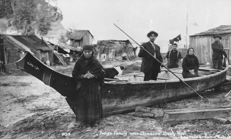
Klallam Indians pose with canoe near Chimacum Creek, Washington, ca. 1914


MULTIMEDIA
The Tse-whit-zen story comes to life in this moving slideshow.
seattletimes.nwsource.com/news/local/klallam/

Flash 6+ required
Klallam people village
MULTIMEDIA
The Tse-whit-zen story comes to life in this moving slideshow.

Flash 6+ required
seattletimes.nwsource.com/news/local/klallam/
Klallam people village

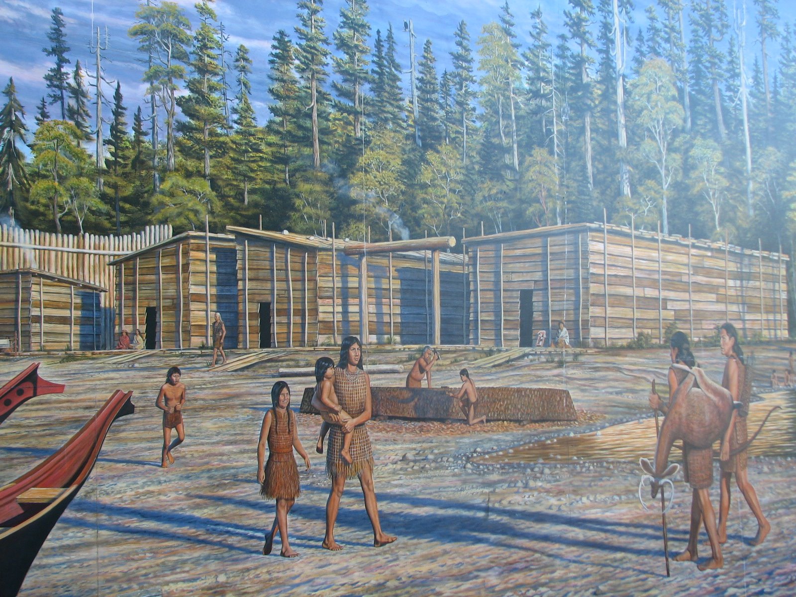
"This depicts the 1750 Indian Klallam Village, I-enn-nus. The name Klallam means 'strong people' in their language. They were primarily a hunting / gathering culture but also practiced forms of agriculture."
"Today many Klallum cultural and traditional practices continue among Native people here on the Peninsula."
cedarpond.blogspot.com/2009_07_01_archive.html
en.wikipedia.org/wiki/File:Klallam_people_at_...
-

Deltaic Habitats in Puget Sound—Natural Versus Human-Related Change
Dec. 2004 / Jan. 2005
Eelgrass in Puget Sound—A New Study of Flow, Sediment Transport, and Zostera marina
September 2004

Coastal and Marine Geology Program
U.S. Geological Survey (USGS)
Delft Hydraulics
Puget Sound Restoration Program
cooperative effort to preserve Puget Soundsoundwaves.usgs.gov/2005/02/research.htmlsoundwaves.usgs.gov/2005/02/research.htmlsoundwaves.usgs.gov/2005/02/research.html


 Narrated slideshow
