
NUEVA ZELANDIA: LA PIEDRA PÓMEZ FLOTANTE PROVENDRÍA DEL VOLCÁN SUBMARINO HAVRE Y NO DEL TONGARIRO
Pumice float traced to eruption of previously dormant Havre volcano: Pacific quake swarm awakened volcano
La erupción del volcán Havre, a mitad de camino entre Nueva Zelanda y Tonga, se cree que causó el vertido de 7,500 km2 de piedra pómez, que fue encontrado flotando como una balsa por un barco de la marina de Nueva Zelanda la semana pasada.

Terra image of the Havre plume and pumice, taken on the morning of July 18, 2012. Courtesy of the NASA Earth Observatory. Note: All images in this post are at approximately the same scale and centered on the same area.
Havre Seamount: The Source of Kermadec Island Pumice Raft - Wired
www.wired.com/.../source-of-kermadec-island-p...
.
LA PIEDRA POMEZ FLOTANTE PROVENDRÍA DEL VOLCÁN HAVRE Y NO DEL TONGARIRO
13 de agosto 2012 - WELLINGTON, Nueva Zelanda - Un enjambre de más de 150 temblores en dos días el mes de julio llevaron a erupcionar a un volcán latente bajo el Océano Pacífico, un científico dijo el lunes. La erupción del volcán Havre, a mitad de camino entre Nueva Zelanda y Tonga, se cree que han causado una gran isla flotante de piedra pómez de 4.000 kilómetroscuadrados que fue encontrado por un barco de la marina de Nueva Zelanda la semana pasada. Cornel de Ronde, científico principal del Instituto de Nueva Zelanda de Ciencias Geológicas y Nucleares, dijo a Radio Nueva Zelanda que la fuente de la piedra pómez se habían identificado en colaboración con investigadores franceses en Tahití que controlan los terremotos en el suroeste del Pacífico. "Cuando miraron sus registros, vieron que el 17 y 18 de julio, habían habido unos 157 temblores de magnitudes entre 3.0 y 4.8," dijo. De Ronde, dijo que eso se produjo cerca de la primera observación de la “balsa” de piedra pómez. "Cuando el Instituto miró a su base de datos, encontró que el volcán Havre era el causante.
Un volcán Caldera, el de White Island en la costa oeste de Norte de Nueva Zelanda, erupcionó la semana pasada, pero se creía que el Havre no había estallado antes, dijo De Ronde. La balsa/isla de piedra pómez era tan ligera que había flotado varios cientos de kilómetros desde el volcán, cuando fue encontrado por el Canterbury HMNZS, que tomó muestras la semana pasada. Los científicos también analizaban muestras de rocas eyectadas desde el monte Tongariro, en el Norte de Nueva Zelanda, para tratar de averiguar por qué entró en erupción hace una semana por primera vez en 115 años. -Sac Bee
.
.
Pumice float traced to eruption of previously dormant Havre volcano: Pacific quake swarm awakened volcano
August 13, 2012 – WELLINGTON, New Zealand – A swarm of more than 150 earthquakes over two days last month caused a previously dormant volcano to erupt beneath the Pacific Ocean, a scientist said Monday. The eruption of the Havre Volcano, about halfway between New Zealand and Tonga, is believed to have caused a floating island of pumice larger than 4,000 square miles that was encountered by a New Zealand navy ship last week. Cornel de Ronde, principal scientist of New Zealand’s Institute of Geological and Nuclear Sciences, told Radio New Zealand the source of the pumice had been identified in cooperation with French researchers in Tahiti who monitor earthquakes in the southwest Pacific. “When they looked at their physical records they saw that on July 17th and 18th, there were some 157 earthquakes of magnitudes between 3.0 and 4.8,” he said. De Ronde said they occurred near the time of the first sighting of the pumice ‘raft.’ When the institute looked at its database, it found the Havre volcano, which it had previously surveyed. It was a caldera volcano, like White Island off the west coast of New Zealand’s North Island, which erupted last week, but the Havre was not thought to have erupted before, he said. De Ronde said the pumice island was so light that it had floated several hundred kilometers from the volcano when it was encountered by the HMNZS Canterbury, which took samples last week. Scientists were also analyzing samples of rock ejected from Mount Tongariro, on New Zealand’s North Island, to try to find out why it erupted a week ago for the first time in 115 years. –Sac Bee
http://theextinctionprotocol.wordpress.com/
Volcano News - John Seach - Monitoring worldwide volcanic activity
August 2012
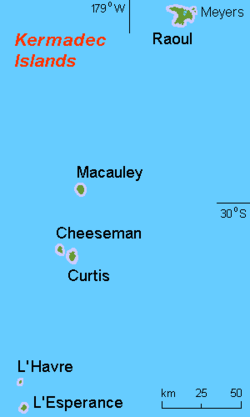
Las Islas Kermadec son una región poco conocida del Anillo de Fuego del Pacífico, están situads entre Nueva Zelanda y Fiyi. La región la forman se compone El Canal Havre, El Arco de Kermadec, y El Sistema de Trasarco de Kermadec. Es un ejemplo de un límite de placa tectónica terrestre en un arco de islas. El concepto de Cuenca de Trasarco se desarrolló inicialmente a partir de estudios de la región de Kermadec.
.
Seguimiento de la actividad volcánica en todo el mundo / http://www.volcanolive.com/news.html / 12 años en el Internet - 2000 -2012
.
Domingo 12 de agosto 2012
Erupción del volcán submarino desconocido, Pacífico Sur
Una gran cantidad de piedra pómez se ha observado flotando en el océano Pacífico Sur a 85 millas náuticas al oeste-suroeste de Isla Raoul. La "balsa" de piedra pómez la observó por primera vez un piloto de avión el 1 de agosto de 2012. La piedra pómez cubre 25.000 kilometros cuadrados. La tripulación a bordo del buque HMNZS Canterbury observó la piedra pómez, el 9 de agosto. La fuente de la piedra pómez no ha sido determinada. More on Kermadec Islands volcanoes...
.
Jueves 09 de agosto 2012
Volcán en White Island, Nueva Zelanda
Un cono de toba, ha comenzado a formarse en el sitio de la erupción en el volcán White Island. La erupción del 6 de agosto 2012 fue la primera en 11 años. Pequeñas cantidades de ceniza están siendo emitida desde el respiradero activo. Los visitantes de la isla enfrentan el peligro de nuevas erupciones. El estado de alerta se mantiene en el nivel 2 (en una escala de 0-5). More on White Island volcano...
.
Miércoles 08 de agosto 2012
Volcán en White Island, Nueva Zelanda
Una pequeña erupción se produjo en el volcán White Island a las 04:55 am el 6 de agosto de 2012. La erupción se produjo en el lago del cráter y fue precedida por fuerte temblor volcánico los días 4-5 de agosto. El lago del cráter había vaciado gradualmente durante 2011 y 2012, y el nivel del agua aumentó rápidamente 3-5 m entre los días 27-28 de julio de 2012. El estado de alerta en el volcán se ha elevado a nivel 2. More on White Island volcano...
.
Martes 07 de agosto 2012
Volcán Tongariro, Nueva Zelanda
El volcán Tongariro entró en erupción a las 11:30 pm el 6 de agosto de 2012. La erupción ocurrió en el cráter Te Mari y duró unos pocos minutos y fue seguida por terremotos más de la media hora siguiente. El refugio Ketetahi Hut fue destruido por rocas volcánicas de 1 metro de diámetro. El refugio está situado a 1,5 km de la erupción. No hubo excursionistas en la cabaña en el momento de la erupción. Las cuatro cabañas del parque nacional en torno al monte Tongariro se han cerrado por razones de seguridad. Nadie resultó herido en la erupción. El estado de alerta en el volcán Tongariro se ha elevado a nivel 2. More on Tongariro volcano...
.
.

.
 http://www.eoearth.org/article/Tonga
August 2006 brought two new things to the Tonga Islands in the South Pacific. One was a raft of lightweight, frothy volcanic rock—pumice—floating on the ocean surface. The other was a new island emerging out of the water. The Moderate Resolution Imaging Spectroradiometer (MODIS) flying onboard NASA’s Aqua satellite captured the aftermath of the eruption on August 10, 2006 (top), at 1:30 UTC (2:30 p.m. local time). For comparison, the bottom image shows the same area on September 15, 2005.
In the top image, the emerging volcanic island is partially hidden by its own plume. Volcanic plumes often appear drab gray or beige compared to clouds, and plumes from the emerging island move away from it in different directions, one to the southeast, and some to the north. The bright white spot directly over the island may be cloud cover, or it could be steam resulting from volcanic emissions.
The raft of pumice appears to the northeast of the emerging island, and it actually connects, via a thin thread, to neighboring Late Island. The blue-green color of the water around the raft and the new island is probably fine sediment that is making the deep blue water more reflective. The pumice raft gained international attention when a news report from Tonga Online described the experience of a yacht crew that inadvertently encountered the pumice raft. The “sea of stone” clogged the yacht’s engine-cooling system, forcing the vessel to turn back.
Pumice rafts are not an everyday occurrence, but they have been observed before. In 1986, a pumice raft of unknown origin caused engine trouble for a Dutch vessel in the South China Sea. Biologists have also proposed pumice rafts as a way to explain how plants and animals spread from island to island in marine environments.
Source: NASA. images by Jesse Allen, NASA Earth Observatory, based on data from the MODIS Rapid Response System, Goddard Space Flight Center.
http://www.eoearth.org/article/Tonga

Bathymetry of the Kermadec volcanic island arc and surrounding areas
.
The Kermadec Islands are a little known region of the Pacific Ring of Fire located between New Zealand and Fiji. The Kermadec region consists of the Havre trough, Kermadec arc, and backarc system. It is an example of an island arc plate boundary. The concept of backarc basin was initially developed from studies of the Kermadec region.
Aves peces y volcanes del Pacífico: Arco de Islas KERMANDEC

The pumice was found half way between New Zealand and Tonga by the NZ Navy while sailing southwest of Raoul Island
.

An area of floating pumice 250 nautical miles in length and 30 nautical miles wide in the South Pacific ocean
.
Volcano News - John Seach / August 2012
Monitoring worldwide volcanic activity
12 years on the internet - 2000-2012
Reports are posted in Eastern Australian Time (UT +10 hr).
Sunday 12th August 2012
Eruption from Unknown Undersea volcano, South Pacific
A large amount of pumice has been observed floating in the South Pacific ocean 85 nautical miles west-south-west of Raoul Island. The pumice raft was first observed by an aircraft pilot on 1st August 2012. The pumice covered 25,000 square km. Crew on board the ship HMNZS Canterbury observed the pumice on 9th August. The source of the pumice has not been determined.
More on Kermadec Islands volcanoes...
Thursday 9th August 2012
White Island Volcano, New Zealand
A tuff cone has started to build over the eruption site at White Island volcano. The eruption on 6th August 2012 was the first in 11 years. Small amounts of ash are being emitted from the active vent. Visitors to the island are at risk from further eruptions. The alert status remains at level 2 (on a scale of 0-5).
More on White Island volcano...
Wednesday 8th August 2012
White Island Volcano, New Zealand
A small eruption occurred at White Island volcano at 04:55 am on 6th August 2012. The eruption occurred at the crater lake and was preceded by strong volcanic tremor on 4-5 August. The crater lake had gradually emptied during 2011 and 2012, and the water level rose rapidly 3-5 m on 27-28 July 2012. The alert status at the volcano has been raised to level 2.
More on White Island volcano...
Tuesday 7th August 2012
Tongariro Volcano, New Zealand
Tongariro volcano erupted at 11:30 pm on 6th August 2012. The eruption occurred at Te Mari crater and lasted a few minutes and was followed by earthquakes over the next half hour. Activity subsided the following morning. Ketetahi Hut was destroyed by volcanic boulders 1 metre in diameter. The hut is located 1.5 km from the eruption. There were no hikers in the hut at the time of the eruption. All four national park huts around Mt Tongariro have been closed for safety reasons. No one was injured in the eruption. The alert status at Tongariro volcano has been raised to level 2.
 ECOLOGÍA DEL ARCO DE ISLAS VOLCÁNICAS KERMANDEC
Las islas son reconocidas por los ecológos como una ecorregión distinta, Los bosques húmedos subtropicales de las Islas Kermadec. Se trata de una ecoregión de bosques tropicales y subtropicales húmedos latifoliados , parte de la Ecozona Oceanía. Los bosques están dominados por el árbol Pohutukawa de flores rojas de Kermadec, afín a los árboles Pohutukawa de Nueva Zelanda. Las islas son el hogar de 113 especies nativas de plantas vasculares, de las cuales 23 son endémicas, junto con musgos (52 especies nativas), líquenes y hongos (89 especies nativas). La mayoría de las especies vegetales se derivan de Nueva Zelanda, aunque algunos son afines a la zona tropical del Pacífico.
152 especies no nativas de plantas introducidas por los seres humanos se han establecido en las islas.
Densos bosques subtropicales cubren la mayor parte de la isla Raoul, y cubrían antes la isla Macauley.
Conservación
La introducción de gatos, ratas y cabras devastó los bosques y las aves marinas. El sobrepastoreo de las cabras eliminó los bosques de la Isla Macauley, dejando pastizales abiertos, y alteró el sotobosque de la isla Raoul. La depredación por ratas y gatos redujo las colonias de aves marinas en las islas principales de millones de aves a decenas de miles. El gobierno de Nueva Zelanda ha estado trabajando durante las últimas décadas para restaurar las islas. Nueva Zelandia declaró a las islas una reserva natural en 1937, y el mar que les rodea como reserva marina en 1990. Las cabras fueron retiradas de la isla Macauley en 1970 y de la Raoul en 1984; desde enionces los bosques han empezado a recuperarse. Actualmente se están realizando esfuerzos para eliminar las ratas y los gatos de las islas, así como algunas de las plantas exóticas invasoras.
Las visitas a las islas se ven limitadas por el Departamento de Conservación. El Departamento permite visitas a Raoul de voluntarios que ayudan en la restauración del medio ambiente o seguimiento de los proyectos, y otros visitantes participan en el estudio de la naturaleza. Las visitas a las otras islas se limita generalmente a los que participan en el estudio científico de las islas.
.